GISS has posted a
report on February temperature, though it isn't in their posted file data yet. It was 1.10°C, up by 0.18°C. That rise is a bit more that the 0.13°C shown by TempLS mesh. It also makes February a very warm month indeed, as the GISS article says. It's the second warmest February in the record - Feb 2016 was at the peak of the El Nino. And it is equal to December 201
65, which was also an El Nino month, and warmer than any prior month, of any kind.
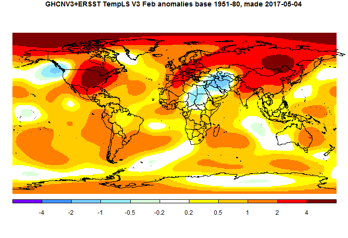
I'll show the plot below the jump. It shows a lot of warmth in N America and Siberia, and cool in the Middle East.
As I noted in the previous post, TempLS had acquired a bug in the treatment of GHCN data that was entered and later removed (usually flagged). This sometimes caused late drift in the reported numbers. It has been fixed. Last month is up by 0.03°C on initial report.
Here is the GISS plot:

And here is the corresponding TempLS plot


I think you mean February's anomaly is equal to December 2015, Nick, not December 2016.
ReplyDeleteIndeed, thanks.
DeleteFebruary 2017 is the fourth warmest anomaly ever, tied fourth with Dec 2015.
ReplyDeleteIn Giss dTs it is the third warmest ever, only February and March 2016 are warmer.
Well, so far, my prediction for 2017 is not in any trouble! 38 straight months of positive PDO numbers.. I don't think that has happened before.
ReplyDeleteA number of interesting patterns becoming apparent. There are reasonable SST measurements of DJF (Southern Hemisphere Summer) in the Southern Ocean since the early-1950s. This Summer was the warmest since the early-1980s, perhaps even late-70s, and much warmer than any Summer from the late-80s through to last year (mostly >0.3K warmer in HadSST3). This would seem to confirm what's being shown by sea ice measurements - that there's something very different currently happening around Antarctica in context of the 1979-present satellite-era.
ReplyDeleteLooks like the March anomaly will also be very high given the ONI. The notion that temperatures have returned to levels that existed before the El Niño is complete rubbish. Wonder if the three honest brokers will say that Lamar Smith?
ReplyDeleteYes. The average for 2017 so far is higher than year 2016, and I think will be so after March.
DeleteIf the ENSO forecast is right, big if right now, then the first 1/4 of 2017 is likely the coldest 1/4. An El Niño starting mid-year 2017 is likely to continue well into 2018. This means there is actually a possibility of 2017 and 2018 being exceptionally warm years, and it's even possible that one or both could set records as being the warmest years in the record.
Delete